Four scenarios likely around Bárðarbunga
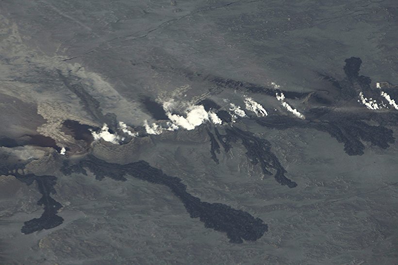
The Holuhraun eruption site. The rift extends 1.000 meters.
Golli / Kjartan Þorbergsson
Scientists from the Icelandic Met Office, the Institute of Earth Science and representatives from the Civil Protection Department met this morning to go over the situation in the area around Bárðarbunga, Dyngjujökull and Holuhraun.
The key points of their meeting are:
- Seismicity remains high with over 700 quakes since midnight, counted at 11:45 GMT.
- The most powerful earthquakes in the area since midnight were a magnitude 4,5 quake in northern Bárðarbunga around 02:35, a magnitude 4,2 earthquake in the same area at 06:18 and 5,4 magnitude earthquake at 07:03 on the southern edge of Bárðarbunga. All times are GMT.
- Around 20 earthquakes have hit around Askja. Outflow of magma into the dyke could explain these tremors.
- Jökulsá á Fjöllum, as well as other rivers north of Vatnajökull show no signs of change in water flow.
- Scientists are examining the fresh lava from Holuhraun.
Currently, there is no way of telling what will happen. Four likely scenarios are given:
- Inflow of magma into the dyke from Bárðarbunga will stop, resulting in the event slowly fading out with no further eruptions.
- The dyke will again break through to the surface north of Dyngjujökull, possibly in a different area than last time but not under Dyngjujökull.
- The dyke might break through under Dyngjujökull, resulting in a jökulhlaup and significant ash fallout.
- An eruption in Bárðarbunga, resulting in a jökulhlaup in Jökulsá á Fjöllum, but also possibly in Skjálfandafljót, Kaldakvísl, Skaftárkatlar and Grímsvötn.
Other scenarios are also possible.
The aviation code over Bárðarbunga remains orange and yellow over Askja.

 Ofsóttur innan veggja Boeing
 Stóraukið fé til samgöngusáttmála
 Hjón sluppu með skrekkinn
 Hafa samþykkt kaup fyrir um 9,2 milljarða
 Fjárfestingin 115 milljarðar króna
 Markaðurinn hitnar og leiguverð hækkar hratt
 Ekki byggt í takt við áform sveitarfélaga