
Severe Weather in Iceland Today
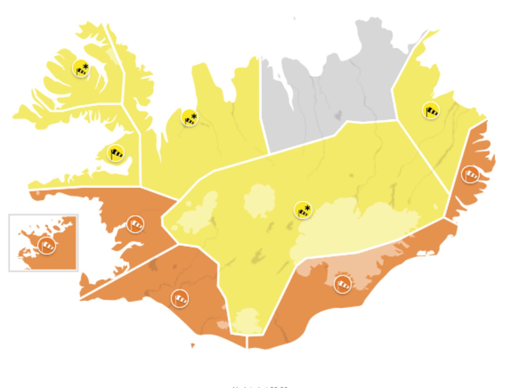
Weather warnings for today. Map/Icelandic Met Office
The Icelandic Met Office has issued weather warnings for almost all of Iceland today. Numerous international and domestic flights have been canceled and so have some buses. In addition, the first out of two ferry rides to Vestmannaeyjar islands today has been canceled.
An orange weather alert has been issued for the capital area, the Faxaflói bay area, South Iceland and the East Fjords. A yellow weather alert has been issued for ther rest of the country, the only exception being Northeast Iceland.
An orange weather alert took effect in the Faxaflói bay area and in South Iceland at 10 am. It will remain in effect until 6 and 7 pm, respectively. A severe westerly or southwesterly gale or storm is expected, with wind gusts in excess of 35 m/sec. Showers of rain and later snow are expected with poor visibility and deteriorating driving conditions. Traveling is not advised. Risk of damages due to flying debris can be expected, and people are advised to secure their surroundings and fasten loose items.
An orange weather alert will be in effect for the capital area from noon till 4 pm. Wind gusts will range from 30 to 38 m/sec. Showers of rain and later snow are expected with poor visibility. People are advised to secure their neighborhood and to show caution. A severe gale is in the forecast for the capital area this afternoon and into the evening.
A severe westerly gale or storm is forecast for Southeast Iceland, with an orange weather alert in effect from noon today until 2 am tomorrow, and from 6 pm tonight until 4 am tomorrow for the East Fjords. Wind gusts will exceed 40 m/s near Mýrdalsjökull and Vatnajökull glaciers. Traveling is not advised. Risk of damages due to flying debris can be expected, and people are advised to secure their surroundings and fasten loose items.
For the rest of the country, with the exception of Northeast Iceland, a yellow weather alert has been issued.
In the Breiðafjörður bay area, a severe gale and snow showers are expected today, with poor visibility and deteriorating driving conditions. For the West Fjords, a northwest snowstorm is forecast in the afternoon and evening. Transport disturbances are likely.
For the eastern coastal areas, a severe gale is forecast from early evening into early morning, with snow showers and poor visibility.
Finally, for the Central Highlands, a westerly blizzard is forecast until midnight, and traveling is not advised.
For an updated forecast, see vedur.is.


/frimg/1/48/1/1480176.jpg)